OBS record underwater eruption, United States
In 2014, a network of Güralp Maris Ocean Bottom Seismometers were deployed in the north-east Pacific Ocean as a part of a multi-million ocean observatory project in the United States. The seismometers provided unparalleled geophysical recordings of a submarine volcanic eruption.
Ocean Observatories Initiative
The Ocean Observatories Initiative (OOI) is an ambitious 25 year project worth US $386 m to develop the world’s largest interactive portal to study the oceans. The University of Washington in Seattle have been charged with the responsibility of installing seismometers, amongst other geophysical equipment as part of an ocean cable observatory.
The aim of the seismic monitoring network was to monitor geological processes in the Juan de Fuca tectonic plate, from its formation at the mid-ocean ridge to its eventual demise in the Cascadia subduction zone. As well as yielding new scientific research, the subsea network can also monitor regional subsea geological hazards, such as large megathrust earthquake ruptures and underwater volcanic eruptions.
Guralp Solution
In 2013, Guralp supplied 10 Maris ocean-bottom seismometers, fitted with 3-component 6T broadband sensors, to the University of Washington. The frequency response of these sensors is 10 s (0.1 Hz) to 100 Hz.
The Guralp Maris has a titanium pressure case that withstands water pressure at up to 2000 m depth and resists corrosion by seawater. The instruments are equipped with a 3-channel digitiser and a SubConn connector for rapid installation into the cabled network.
The University of Washington deployed the instruments in summer 2014 across the northeast Pacific Ocean in water depths ranging from 800 to 1500 m. The installations were carried using a remotely operated underwater vehicle (ROV), which buried the instruments into sediment on the seafloor. In September 2014, the instruments were switched on.

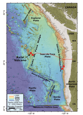
Map showing the location of the seismic networks containing the Güralp Maris instruments (red squares). The approximate location of the seafloor cable is given by the red line.
Outcome
In January 2015, data from the cabled OBS network was released to the public via the Incorporated Research Institutions for Seismology (IRIS) Data Management Center (DMC). The network of five Maris OBS stations deployed in and around the summit caldera made unprecedented high quality recordings of the submarine eruption of Axial Seamount volcano in April 2015.
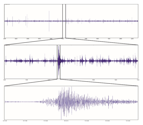
On average, 100-200 micro-earthquakes were detected by the monitoring network each day. On 24 April 2015, the daily earthquake count reached nearly 8,000 events. The majority of seismic events were located on the east side of the volcano’s caldera. The OOI continues to provide real-time data, providing new insights into the geological processes inside ocean plates and their associated hazards.
On average, 100-200 micro-earthquakes were detected by the monitoring network each day. On 24 April 2015, the daily earthquake count reached nearly 8,000 events. The majority of seismic events were located on the east side of the volcano’s caldera. The OOI continues to provide real-time data, providing new insights into the geological processes inside ocean plates and their associated hazards.


