

Natural Resources Canada develop Canada's new Earthquake Early Warning system with 190 Güralp Fortimus instruments
Background
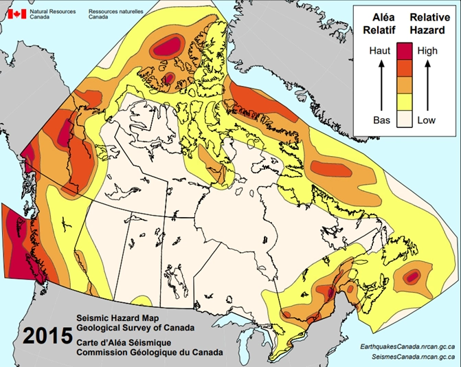
Seismic risk in Canada is largely fault driven. Risk in British Columbia arises from the active subduction zone along the west coast of Vancouver Island and extending southward as far as northern California, from which a megathrust type event could result in earthquake magnitudes of 9.0 or greater. Additionally, the Queen Charlotte Fault, along the west coast of Haida Gwaii, has a history of significant earthquakes, including a magnitude 8.1 in 1949 and a 7.8 in 2012. In Eastern Canada, the western Quebec seismic zone can produce earthquake magnitudes of 7.0 or greater. Events in Arctic Canada mostly result from post glacial rebound and faults extending from Alaska into Yukon territory stressing convergent margins, also pose significant risk to infrastructure.

Figure 1: Seismic Hazard Map of Canada. Source: Geological Survey of Canada

Seismic monitoring
For this, NRCan has developed an EEW system, consisting of a large number of sensor stations close to areas at risk from a major earthquake. This system will help protect significant populations and critical infrastructure by providing seconds to tens-of-seconds of warning before the arrival of strong shaking.
Multiple low-latency communication links to dedicated data centres and software systems are essential components of an effective EEW system, ensuring reliability and redundancy. Together these allow for measurements to be processed and autonomous warnings to be given to residents, emergency services, critical infrastructure operators and government bodies in the event of an earthquake.
Project requirements
The stations of the new NRCan network are to be installed throughout populated areas at risk from a major earthquake. They must be compatible and efficient in a large network that may involve drastically variable noise conditions. For this, extensive configuration options are desirable.
Güralp Solution
Extremely lightweight and portable at 1.9 kg, Fortimus measures 84mm x 165mm, making field deployment a simple task. The LCD touchscreen display acts as a systems interface to provide sensor feedback and levelling information during deployment.
The Fortimus has a wide output acceleration response band of DC - 315 Hz and allows for a range of user-configurable settings, including a remotely adjustable gain of ±4 g, ±2 g, ±1 g or ±0.5 g. The Minimus also allows the user to monitor the instrument State of Health (SOH) by providing access to a variety of internal environmental data channels. These features allow NRCan to effectively manage the large network and ensure optimal performance.
The Fortimus is capable of streaming multiple data feeds independently, prioritizing the highest data quality with the lowest latency. Multiple instruments can be bulk updated with configuration files making them particularly suited to networked arrays over large distances. Fortimus is configured via a user-friendly interface, which includes admin and user logins to protect against unauthorized data loss

Fortimus digital force-balance accelerometer
Deployment
A total of 190 Fortimus instruments have been supplied to NRCan, with additional units supplied to project collaborators. Güralp instruments were installed by NRCan in the remotest areas and, in locations close to the major urban centres, by Güralp’s project partner, ESG Solutions of Kingston, Ontario.
Most sensors are installed in surface vaults (figure 3-5). 70% of these are in urban indoor settings, 20% urban outdoor, and 10% wilderness. These stations communicate via Internet, Cell modem, IP radio or Satellite depending on the nature of the location.
The wide functionality of the Fortimus sensors and their in-house digitizers allows for each installation type to operate at ultra-low latency, combining to provide an effective EEW system. Live waveform data are streamed to two physical data centres, where data processing and alert communications are managed. These NRCan data centres transmit prompts via radio, television, internet and cellular networks
Güralp Data Centre (“GDC”) software was developed for the project to handle data acquisition requirements from the Fortimus stations into the NRCan network.

Figure 3: Fortimus sensor placed in vault and cabled in

Figure 4: Control box for battery power supply and modems. Black boxes below contain batteries to power the sensor.
Outcome
This large-scale strong motion network also provides Canada with valuable data to better understand the risk of seismic events. Regular reports and the production of hazard maps helps inform decisions on building policy to mitigate any damage from future strong earthquakes.
By protecting residents from seismic risk Canada will also raise its earthquake awareness. This will encourage residents at risk to protect their property from disaster, as a result the whole country will become more economically resilient and able to respond more rapidly in the aftermath of a potentially damaging seismic event.
Güralp is proud to have worked with Canada on such a vitally important project.
More information on the system can be found online at: https://www.earthquakescanada.nrcan.gc.ca/eew-asp/system-en.php